


INSURANCE SATELLITE REMOTE SENSING
Prix : 1-12 USD/km²
Combining satellite remote sensing technologies with rights confirmation data and land parcel segmentation technology can vectorize and spatialize the subject matter of insurance, then establish a spatial database of the subject matter of insurance to provide spatial data and analysis management support for insurance underwriting and claim settlement.
SATELLITE REMOTE SENSING FOR AERIAL IMAGERY ANALYSIS INSURANCE FEATURES
1
Accurate Risk Assessment: Satellite aerial imagery analysis insurance can provide detailed information on properties, such as their size, shape, location, and condition. This can help insurers to accurately assess the risks associated with a property and determine appropriate coverage and premiums.
2
Data breach coverage: Satellite aerial imagery analysis insurance often involves handling sensitive data, which can be vulnerable to cyber attacks. This aerial imagery insurance can provide coverage for data breaches and associated costs, such as legal fees, notification expenses, and credit monitoring services.
3
Data Analytics and Predictive Modelling: Satellites used for remote sensing in insurance can provide insurers with a wealth of data that can be used to develop predictive models and identify patterns and trends. This can help insurers to better understand risks and make more informed decisions about coverage, premiums, and underwriting.
4
Improved Underwriting: Satellite aerial imagery analysis insurance can help insurers to identify and evaluate risks that may not be visible through traditional methods, such as physical inspections or surveys. This can lead to more accurate underwriting and better risk selection.
5
Enhanced Customer Experience: By leveraging satellite aerial imagery analysis, insurers can provide their customers with more personalized and customized insurance solutions, based on the specific risks associated with their properties. This can lead to increased customer satisfaction and retention.
Chang Guang Satellite Technology Co., Ltd. is a satellite factory, we provide aerial imagery analysis insurance, aerial imagery insurance, satellite data service, etc. For more information, please feel free to contact us!
Personne à contacter : global jl1, 0431 81785188
Bonne affaire : acheter au vendeur
Nous vous invitons à lire nos conditions générales d'utilisations. Vous pouvez aussi vous rendre sur nos FAQ et consulter notre page d'informations sur les risques liés à la contrefaçon.
|
Cette page concerne les importateurs et exportateurs de INSURANCE SATELLITE REMOTE SENSING Rechercher dans la catégorie : Pro / B2B Rechercher dans la catégorie : remote, sensing, satellite, insurance |
Signalez un abus
Saturday 11 July 2015
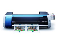
Quantité : 1 - Prix : $3,429.00
Truly affordable. Remarkably versatile. With the VersaStudio, we've taken everything that makes a Roland printer great and packed it into one powerful, profit-producing package. Award-winning mild solvent inks. Your choice of media. One device that can print and cut an incredible...
Asia Toner Inc
- 12950 - Jakarta
- 6281361223405
Signalez un abus
Friday 18 January 2013
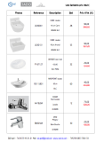
Quantité : 332 - Prix : 28 830,00 €
Data Categorie Reference Description Qté P/Public Prix unitaire Total de la ligne LAVABO L630001 CUBIC LAVABO RESINE 40 CM BLC CARRE 28 848,60 € 80,00 € 2.240,00 € L630101 CUBIC LAVABO RESINE 40 CM BLC ARRONDI 53 927,20 € 90,00 € 4.770,00 € P167127 ODYSSEE LAVE-MAINS PERG...
Z&D sprl
- 1070 - Anderlecht
- +32 4 72 49 61 01
Signalez un abus
Tuesday 12 May 2026
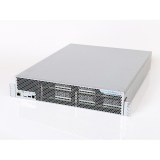
Quantité : 20 Unit - Prix : $836
Price: US $836 Site: azriadi.com Accept paypal The SP31 included an improvement to the ASICs that delivered more hashing for the same power consumption. With the SP35 we replaced the PSUs to squeeze out even more out of the RockerBox ASICs. This new design will deliver 5.5TH/s...
Paiement sécurisé